The Airport Cemetery
Sunday, 26 February, 2017 — mapping development
My wife, Robin, and I visited the cemetery at Raleigh-Durham International airport after lunch Saturday, prompted by a discussion I had on Twitter earlier in the week with aviation geeks and meteorologist Nate Johnson.
Nate started with his surprise that Chicago’s O'Hare International Airport has a cemetery. That was also news to me, but I was reminded of the small cemetery at RDU. I figured Nate also knew it. But, no, it was news to him, and I suspect it’d be a small surprise to a lot of folks.
Robin and I have used RDU’s ParkRDU Economy Lot 4 for our occasional trips out of town, and on the drive in, we’ve passed Cemetery Road and seen a little bit of fencing. So, I knew it was there. But, it’s out of the way and for folks accustomed to coming and going from the airport via Aviation Parkway or Airport Blvd, they might never pass by. Even if you drive up to the Observation Park and then out to Lumley Road, you might miss it.
Here it is from using Google Maps’ satellite view:
Robin and I were in the area and, given the discussion from earlier in the week, we decided to drop by. There’s a chainlink fence around the cemetery and a small driveway, enough for two or three cars. There’s a pedestrian gate in the chainlink fence and a double swinging gate up a gravel and grass incline to allow vehicle traffic.
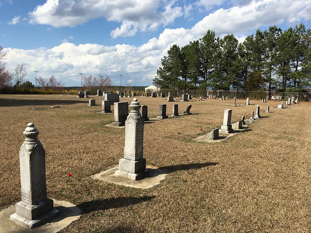
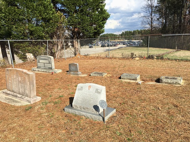
We walked around, looking at headstones and took a few photographs.
Here’s a view of the headstones looking diagonally SE to NW across the cemetery towards Runway 5L-23R:
This view is SW to NE, where cars parked in Lot 4 are visible in the background:
Finally, the sign that offered a clue about the history of the cemetery:
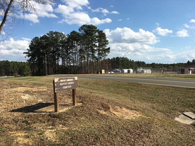
The name Mt. Hermon Baptist Church struck a memory. I thought I remembered that church north of the airport, off of Leesville Road, just into Durham County. Looking at a map on my iPad, I could also see a Mt. Hermon Road running north and south that terminated on the north side of the Glenwood Avenue interchange with I-540. But, looking further, there was a continuation of the road on the south side of the interchange, crossing to Lumley Road and continuing as Commerce Blvd on the airport itself. (View on Google Maps)
That struck me as interesting and probably meant that it was contiguous at one time, before I-540 was built, beginning in 1992. Later in the afternoon, I went out for a walk and thought about where I might find a map of northwest Wake County from before I-540’s construction. I was thinking that I’d end up at the library looking for county property maps (and that will still be valuable), but, for whatever reason, I instead remembered the US Geological Survey’s topographic quadrangles. If I could get a past version of one of those, I might learn something.
As it happens, the USGS does have historical quads online in a variety of formats (PDF, TIFF, JPEG, etc) and scales. Using their TopoView tool, I was able to narrow down available maps for the area and then look at past dates. As it happens, there’s a 1982 edition map of the SE Durham quadrangle using 1973 survey data (large JPG).
Looking at the lower-right corner, there are a few things that we can see. One item is that Mount Hermon Road, labeled as Route 1646, is fully connected, with an interchange at Glenwood Avenue (U.S. 70). We see the absence of Interstate 540. Following Mt. Hermon Road south from Glenwood, we see the cemetery and a Mt Hermon Church on the map. Continuing south, we see that Runway 5L-23R does not yet exist. (It appears on the 1993 edition, but not on the 1991 edition 1:100,000 scale wider map from 1990 survey data, which is interesting because RDU history says the runway opened in 1986.)
The church congregation appears to have moved from what becomes a taxiway around the General Aviation apron, to Olive Branch Rd in Durham County. The cemetery is still taking newer burials. The newest burial we found is from Feb. of 2016.
This leaves me wondering when the church moved. I see there was a small cluster of buildings as an unincorporated settlement on the 1973 map, labeled Hermon. Digging into that might require looking at past census data and property tax records at the county level.
I’m fascinated by all of this and wonder how this all played out. Accordingly, there’s some interesting research to do yet in order to learn at least part of fuller history here. I will have a follow-up post when I do.