I spent a lot of time reading and writing on Twitter in 2017. I haven’t pulled
together a 2017 corpus of tweets, but there’s some thinking I was happy to
share in thread form. There’s also a fair amount of time I spent that I’d
struggle to consider as well-spent on Twitter.
Mentally, I’m ready for something different than what I’ve been doing. Twitter’s
format, even at an expanded 280 characters, doesn’t encourage me to develop my
thinking and writing the way I would like.
I want my writing to embody and encourage proactive thinking. Both in myself as
a writer, and hopefully within whatever audience I’m fortunate to have read
this. I want write less from a reactionary perspective. Some of that this past
year has been snark. Some has been shouting into the void at various horrors
politic. I think my motives are fine, but I can better channel the writing I do
than I have been.
My hypothesis is I’m better writing thoughts on a particular topic out in long
form. I’ll set it down for at least a bit, then return to edit and refine. I’ll
post it on this site and then share a link on Twitter. I think I’ll have better
work than the work I produce hashing out my thinking in an unwieldy and
uneditable Twitter thread.
I’m interested in quoting and linking with citations to source material. I’m
interested in updating a piece, fixing misspellings or poor phrasing when I find
it.
Twitter as Endless River has been easy for me to indulge in as a lazy writer and
lazy reader, particularly given a pretty busy year at work. Flick, scroll, open
some tabs, maybe read them, refresh, repeat. My fear of giving in to laziness as
both a writer and a reader is that said laziness encourages lazy thinking.
Here, I control my words. Nobody can shut this site down, run annoying ads on
it, or sell it to a phone company. Nobody can tell me what I can or can’t say,
and I have complete control over the way it’s displayed. Nobody except me can
change the URL structure, breaking 14 years of links to content on the web.
I like that approach, too. It’s the approach I’m using for this site. Similarly,
there are services like micro.blog to provide longer, non-siloed
places to write. I’m interested in RSS and JSON feed as content
sharing mechanisms. I’m keenly interested in writing on and for the Open
Web.
Here, I can post as much or as little as I (and I’m guessing with this), my
audience can stand on a given topic. If a post needs 3,000 words, that’ll
happen. That’s going to be far easier to read here than a 60 tweet thread,
whether or not I used Twitter’s new threading tool. If I want to post a lot
fewer words, perhaps just to say I liked a link, this site should fit that need,
too.
I’m interested in approaching where I read and what I read in 2018 differently.
Specifically, putting more emphasis on reading clear, articulate writing from
others outside of Twitter.
My hypothesis is that active, considered reading will lead to more considered
thinking. That will lead to active, considered writing. I plan to be doing more
of that here this next year.
I’m launching a photography newsletter that will be published approximately
monthly. The first issue will be out within the next week or so.
I’ll be focusing the newsletter on highlighting new work from me and revisiting
some older work I want to shine a light on. I’ll share lessons and experiences from my 22 years of active photography practice and work from other folks that
I find interesting and inspiring.
Finally, I’ll be offering photos for sale soon, and this newsletter is going to
be a great spot to hear about it.
This was the largest group I’ve presented to so far. While work began on the
talk in February, 2017, I ended up working on it until about 45 minutes before I
went on stage. I’ll have a separate “lessons learned” post about the talk and
things I would like to do with the talk material in the future, focused primarily on some data I wanted to analyze in more depth, but did not get to.
That said, I enjoyed the heck out of putting this talk together and presenting.
I could sense that points I wanted to emphasize were coming across based on the
audience’s body language. The coworkers who directly experienced the
circumstances I walk through in the talk said I represented those times well.
I’ll take all of that as a win.
My thanks to Confreaks for their recording and production work.
My wife, Robin, and I visited the cemetery at Raleigh-Durham International
airport after lunch Saturday, prompted by a discussion I had on Twitter earlier
in the week with aviation geeks and meteorologist Nate Johnson.
Nate started with his surprise that Chicago’s O'Hare International
Airport has a cemetery. That was also news to me, but I was reminded of the
small cemetery at RDU. I figured Nate also knew it. But, no, it was news to him,
and I suspect it’d be a small surprise to a lot of folks.
Robin and I have used RDU’s ParkRDU Economy Lot 4 for our occasional trips out
of town, and on the drive in, we’ve passed Cemetery Road and seen a little bit
of fencing. So, I knew it was there. But, it’s out of the way and for folks
accustomed to coming and going from the airport via Aviation Parkway or Airport
Blvd, they might never pass by. Even if you drive up to the Observation Park and
then out to Lumley Road, you might miss it.
Here it is from using Google Maps’ satellite view:
Robin and I were in the area and, given the discussion from earlier in the week,
we decided to drop by. There’s a chainlink fence around the cemetery and a small
driveway, enough for two or three cars. There’s a pedestrian gate in the
chainlink fence and a double swinging gate up a gravel and grass incline to
allow vehicle traffic.
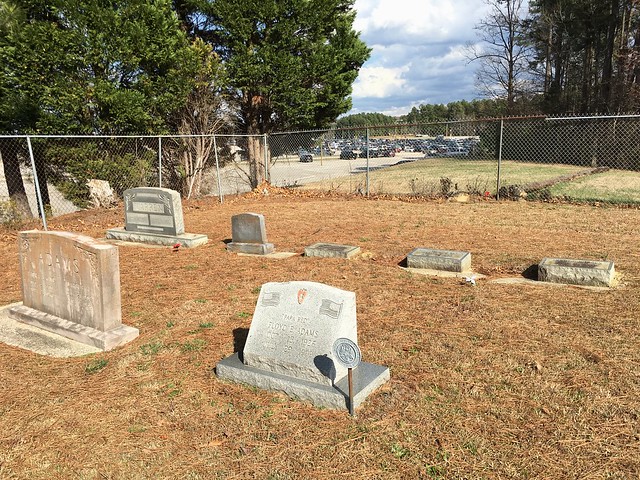
We walked around, looking at headstones and took a few photographs.
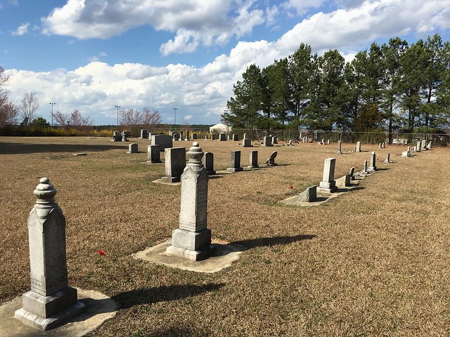
Here’s a view of the headstones looking diagonally SE to NW across the cemetery
towards Runway 5L-23R:
This view is SW to NE, where cars parked in Lot 4 are visible in the background:
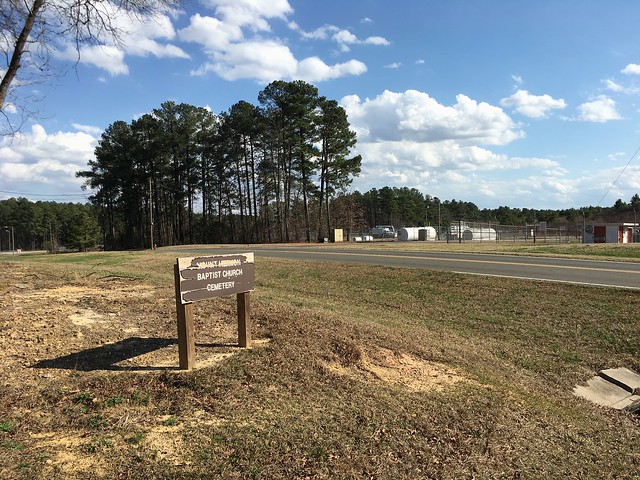
Finally, the sign that offered a clue about the history of the cemetery:
The name Mt. Hermon Baptist Church struck a memory. I thought I remembered that
church north of the airport, off of Leesville Road, just into Durham County.
Looking at a map on my iPad, I could also see a Mt. Hermon Road running north
and south that terminated on the north side of the Glenwood Avenue interchange
with I-540. But, looking further, there was a continuation of the road on the
south side of the interchange, crossing to Lumley Road and continuing as
Commerce Blvd on the airport itself. (View on Google Maps)
That struck me as interesting and probably meant that it was contiguous at one
time, before I-540 was built, beginning in 1992. Later in the afternoon,
I went out for a walk and thought about where I might find a map of northwest
Wake County from before I-540’s construction. I was thinking that I’d end up at
the library looking for county property maps (and that will still be valuable),
but, for whatever reason, I instead remembered the US Geological Survey’s
topographic quadrangles. If I could get a past version of one of those, I might
learn something.
Looking at the lower-right corner, there are a few things that we can see. One
item is that Mount Hermon Road, labeled as Route 1646, is fully connected, with
an interchange at Glenwood Avenue (U.S. 70). We see the absence of Interstate
540. Following Mt. Hermon Road south from Glenwood, we see the cemetery and a Mt
Hermon Church on the map. Continuing south, we see that Runway 5L-23R does not
yet exist. (It appears on the 1993 edition, but not on
the 1991 edition 1:100,000 scale wider map from 1990 survey data,
which is interesting because RDU history says the runway opened in 1986.)
The church congregation appears to have moved from what becomes a taxiway around
the General Aviation apron, to Olive Branch Rd in Durham County. The cemetery is
still taking newer burials. The newest burial we found is from Feb. of 2016.
This leaves me wondering when the church moved. I see there was a small cluster
of buildings as an unincorporated settlement on the 1973 map, labeled Hermon.
Digging into that might require looking at past census data and property tax
records at the county level.
I’m fascinated by all of this and wonder how this all played out. Accordingly,
there’s some interesting research to do yet in order to learn at least part of
fuller history here. I will have a follow-up post when I do.
Earlier this month, California was getting slammed with torrential rain and lots
of snow, leading to road closures in the Sierra Nevada mountains.
Having lived in the Central Valley of California, where the Sacramento news
stations would send a reporter up the mountain to report on road conditions
along Interstate 80 when snow started falling, various highway closures across
the crest of the Sierras isn’t particularly unusual. There are a number of state
roads that close for the winter, but a number stay open, too, depending on what
conditions are.
I was surprised, however, when I read that cars were getting stuck on the
Eastern Slope, just before they’d cross into California. They were trying to
route around I-80 being closed:
VERDI, Nev. (News 4 & Fox 11) —
Interstate 80 has been closed over Donner Pass at least three times in the month
of January. Many drivers searching through an alternate route through the Sierra
are ending up stranded in the snow on Dog Valley Road near Verdi.
“If weather conditions are bad enough and a major thoroughfare like I-80 is
closed, what do you think conditions are going to be like on a single-track
dirt road that winds its way through the mountains? They’re not going to be
safe.”
…
“When Interstate 80 is closed, Google Maps wants to take them this way,”
Search and Rescue volunteer Jack Wayman said, “and even with signs that are
posted saying ‘don’t go this way,’ ‘don’t trust your GPS,’ they’re still doing
it.”
Many drivers - some of them behind the wheel of big rigs - are using
navigation systems to search for alternate routes through the Sierra. This
comes as more people are putting their trust in technology when they travel.
For the I-80 case, at least Google/Waze are able to make an adjustment, which is
great.:
Update: That was surprisingly efficient. Made it to some
folks on both teams. Ah, the wonderful, terrible internet.
Besides temporary road closures and “helpful” algorithms guiding users off of
freeways onto two-lane mountain roads, this is also a problem that’s plagued
other uses of GPS.
Death Valley has been one such case. NPR reported in 2011 on GPS and
turn-by-turn navigation systems prompting drivers to head down non-existant
roads in Death Valley:
Meanwhile, he (Death Valley Ranger Charlie Callagan – ed) says, he’s been
asking himself, what exactly is going on? Why is the GPS going astray? Then,
he had an idea.
To explain, he drives out to a lonely corner of the valley. A line pops up in
the corner of my GPS screen. Supposedly, it represents a road about to
intersect the one we’re driving on. But looking out the window, there is no
other road.
“That road there no longer exists. It’s been probably 40 years, but somebody
ended up driving on it because it showed up on their GPS,” Callagan says.
In a tragic case from 2009 that the NPR story mentions, but The Sacramento Beegoes into more depth about, a six-year-old, Carlos Sanchez, died after he
and his mother became stuck in a remote section of Death Valley:
[Alicia] Sanchez was trying to drive into Death Valley from the south via an
unpaved route along the valley floor called the Harry Wade Road. Instead, she
ended up on a dead-end backcountry road, which she followed for more than 20
miles along the south side of the Owlshead Mountains.
“The road is very rough. It’s a hard drive,” said [Death Valley ranger Amber]
Nattrass. “There was probably a point where she said, ‘Oh my God, I don’t know
where I am. I’m going to keep going because I think I’m going the right
direction.’
"A lot of people don’t realize you should just turn around and go back the way
you came,” she said. “We see that a lot here.”
Near where the road ends, Nattrass followed the tire tracks that turned onto
“a closed road in the wilderness area going over several small bushes and
rocks lined along the road to designate closure,” her report says.
And it was down that road – on Aug. 6, 2009 – that Nattrass spotted the Jeep
stuck up to its axles in the sand with SOS spelled in medical tape on the
windshield. Alicia, then 28, a nurse from Las Vegas, was lying next to it in
the shade, distraught over the death of her son and so dehydrated she had been
drinking her own urine.
The NPR story reports that road information for Death Valley was updated by
TomTom with updates for other mapping data providers pending.
I’ve heard of, but can’t find a link right at the moment, cases in the United
Kingdom of trucks (sorry, lorries) getting stuck on hedge-lined, single-lane
roads because their navigation systems take them there without regard for the
width of their vehicle. Something similar is happening in Arkansas.
Where this gets personal is back in August, 2016, my wife Robin and I were
visiting a group of friends for a weekend retreat in Virginia. We were staying
at a bed and breakfast in Lovingston, just off of U.S. 29. We’d meet
them at a home north of Shipman. Getting from the bed and breakfast, at least
the way Apple Maps showed us, was a six mile/10 minute trip up and over the
mountain.
However, the directions our friends gave us were much different. Closer to 11
miles and 25 minutes. This hurt my brain a bit, and so I asked our hosts why
what looked like the more direct way wasn’t what they recommended. The answer
was Hurricane Camille. In 1969, Camille brought torrential rains and
caused a landslide along the road, among with many other horrific problems for
Nelson County, Virginia.
Once our retreat was over, we drove as far down the east-end of the road as we
felt comfortable and, sure enough, nothing we’d reasonably call a road was
available to us.
So, while Apple Maps still shows a connected road across the mountain, looking
at satellite imagery, there’s some track work into thick tree stands, but that’s
it.
Clearly, using some thought as a driver is required. Local conditions out the
window beats whatever satellite-assisted turn-by-turn navigation is saying is
happening. But, in the absence of the kind of knowledge and experience you gain
driving around a city or rural stretch for months and years, leaning on
automated navigation is comfortable and attractive. Frankly, it also works a lot
of the time, so granting trust is easy.
My curiosity from all of this is how automated navigation systems and paper map
data are updated with ground truth. I intend to explore that as a topic further.